If you know anyone from the Okeson, Eklund, Richardson, Schlottman, Torgerson, or Thompson families from North Dakota or Oregon, please help
identify these photographs!
![]()
If you know anyone from the Okeson, Eklund, Richardson, Schlottman, Torgerson, or Thompson families from North Dakota or Oregon, please help
identify these photographs!
![]()
I never would have been President if it had not been for my experiences in North Dakota." - Theodore Roosevelt
When the Flood of '97 happened, I was living as a graduate student at the University of North Dakota in Grand Forks, North Dakota. In case you're wondering what life is normally like there, here are a couple of photos I took during a rollicking parade in the fall of 1994. Please click each little picture to see the bigger picture.


Next are some pictures that I took before I evacuated. They were taken about a week to three weeks before I left, which was around April 19th, 1997. I decided to write my thoughts down concerning each photo, in order to help explain each picture and some of the circumstances of the situation. Snow is still visible in most pictures since it snowed not too much earlier that same month.
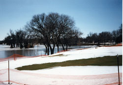
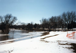
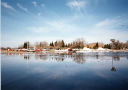
| The first two pictures are from Lincoln Park, which is on the east side of Grand Forks. They were taken about a week before the evacuation in which I left. The icy lake is covering the golf course that usually exists on this spot. You can see the orange fence that marks the edge of a green. I believe that this is close to the sixth or seventh hole, but since I have only played on this course once or twice and several years ago, I only think that is about right. Most of the 18 hole golf course is in a low area, compared with the city, with the back nine flooding first and the front nine flooding later. The greens in this picture and the first two holes, which are not in this picture, are level with the surrounding neighborhoods. The lowest spot in the surrounding neighborhoods is a dip in Belmont Road, where many of the first leaks occured. Belmont Road is visible in both of these pictures and is parallel with the park. In these pictures, it is covered with a dirt and clay levee. It is not unusual for this golf course to flood, but what is unusual is the characteristics of the flood water and the levee covering Belmont Road. In the flood the year before, much of this park flooded, although the water obviously did not get as high or stay as long. I remember looking at the water then and seeing a big lake or pond, with waves and action and water more blueish than not. But this year, as you can see, the water was much different. Most of the water is icy and white and this made the flooded area look much more like a frozen ice rink. It was very still and the water had a chunky, alien appearance. As I mentioned, the levee in the background was built over Belmont Road and eventually did let water through.
The second picture is closer to Belmont Road than the first. Each picture captures a different fenced area, so don't let the orange fence that is visible disorient you.
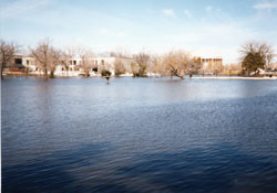
I believe that it was in this area that the first rumours of broken levees started. On the Wednesday before the evacuation, radio announcers said that this levee has sprung a leak, which incited homeowners and other onlookers to rush to the area to evacuate their stuff and get their kids out of school. The leak turned out to be more like a faucet than a hydrant and so the traffic jam and panic that ensued was unnecessary and avoidable. This event should give evidence to the stressful situation that had captured the citizens of the area, as well as the irresponsible, in my opinion, reporting of rumours and advice-giving that was occuring, too. This picture is of the Cooley that runs through the University grounds. The white building in the background is the Fine Arts Building and the Chester Fritz Audiotorium and the President's house are also visible. If you look closely out on the water, you can see the top of a fountain sticking out of the water. Usually this is a peninsula that the Cooley snakes around. The fountain is the centerpiece of a grassy area where the students can congragate. I believe that to the right is a walking bridge that is covered in water. The visible portion is the handrail.
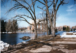
Here is another picture of the Cooley. The Chester Fritz Audiotorium is more visible as well as the top of another walking bridge. The visible portion of that bridge is the handrail.
|
Here is a picture of the Cooley passing under the bridge on University Drive.
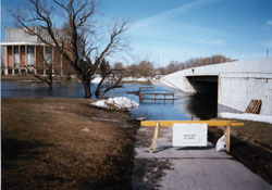
And here is the parking lot that is right behind Wilkerson. Wilkerson is not visible, but is to the left of the picture. The brick building in the distance is the North Dakota School for the Blind, which does not share this same parking lot. Wilkerson, though, is a dormitory that also has a cafeteria and a little grocery/eatery. This parking lot serves several other dorms, but the flooded part is closest to Wilkerson. In fact, the Cooley that passes right by, would have flooded into the front door of Wilkerson except for the sandbags that prevented it. Orange cones are setup to prevent cars from attempting to drive or park in the flooded areas. There is also a bike path that goes from University Drive past the parking lot and the Cooley that I am standing on when I took this picture. It was flooded in this area and, closer to Wilkerson's front door, was the place where the sandbags made their standoff. Apparantly, the bike trail was damaged where this standoff was, because I noticed that it had been repaved there later on that summer
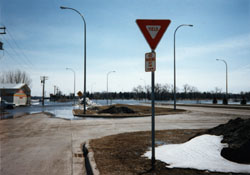
And the last two are from Gateway Drive, which is on the North side of Grand Forks. The first picture was taken coming from the west from roads such as Highway 2 or Interstate 29. Normally, Highway 2 turns into Gateway Drive just before this and goes east through town, until it reaches the Red River and crosses into Minnesota. This portion of Gateway Drive is closed and protected by National Guardsmen because of the flooding. Most of this flooding was not directly from the river itself, but from the English Cooley that heads north from the University of North Dakota. It is this Cooley that normally passes under Gateway, but instead, crested earlier than the Red River and blocked the road.
The second picture is of the same flooded section of Gateway Drive from the other side. Gateway Drive here stretches west to the intersection of Columbia Avenue and Gateway Drive, straight ahead. Columbia Avenue goes right and left (North and South) and Gateway, which normally keeps going to Highway 2 and Interstate 29, is closed here and forces travelers to go on Columbia. Another National Guardsman is at the intersection preventing traffic down that portion of Gateway. Also, next to the Guardsman are the beginning of the sandbags that will be placed here to prevent further flooding of this area. To the left of the picture is a cemetary and to the right are businesses and restaurants. There is also a residential area behind me, which is not far from where I used to live, before the evacuation.
|
Flood Information
UND's Flood Follow-up
University of North Dakota
Red River Valley Basin Flood Page
Pioneer Planet - Flood Central
CNN - Apr. 23, 1997
NOAA Network Information Center Local Forecast for Grand Forks, North Dakota
|
This URL is https://okeson.tripod.com/flood.htm Author: Gregory Okeson This page was last updated June 20th, 2008. This page has been accessed |
| If you're close to Temple, Texas, drop by Gandy's Barber Shop and get a hair cut from Phil. He does quality work and will also make hospital and house calls by appointment. | 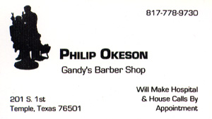 |